|
The Arrival of
the Sea Breeze:
A typical sea breeze
day will dawn warm, calm and sunny. The temperature rises quickly in
the strong sunshine and is soon in the mid to high 20s Celsius by
mid-morning. It is now, under these conditions that the sea breeze
may arrive and with it a relief from what would be a scorching
afternoon. Figure 1 shows the arrival of a sea breeze on what turned
out to be one of the hottest days of the year when temperatures were
as high as 35oC across parts southern England. The
temperature rose rapidly after a warm night and by 11:00am it was
already 28oC, the air was humid and oppressive with just
a slight, variable wind of around 1 mph. Patchy cumulus cloud was
developing in the sky but by 12:30 there was a clearance moving up
from the south, this heralds the start of the sea breeze as it moves
inland suppressing cloud formation and bringing crystal clear, deep
blue skies with a welcome drop in temperature and humidity.
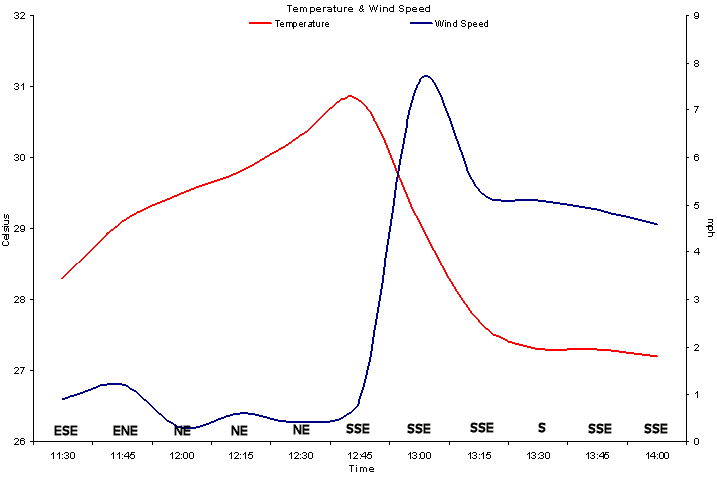
Figure 1. Temperature and
Wind Speed (with wind direction) for the 19th July 2006
demonstrating the arrival of the sea breeze at 12:45.
The temperature drop
associated with the sea breeze on the 19th of July was not as great
as it would have been earlier in the summer and spring time. This is
because the sea was already quite warm by mid-July with sea surface
temperatures approaching 20oC. The drop in relative
humidity as the sea breeze arrives with the associated temperature
drop, wind speed increase and change of direction is shown in the
data set in Table 1.
Table 1. 15 minute
data set from AWS for July 19th, 2006.
|
Time |
hPa |
oC |
RH% |
MPH |
Direction |
|
11:30 |
1014.2 |
28.3 |
48 |
0.9 |
ESE |
|
11:45 |
1014.1 |
29.1 |
46 |
1.2 |
ENE |
|
12:00 |
1013.9 |
29.5 |
47 |
0.3 |
NE |
|
12:15 |
1013.9 |
29.8 |
48 |
0.6 |
NE |
|
12:30 |
1014.0 |
30.3 |
49 |
0.4 |
NE |
|
12:45 |
1014.0 |
30.8 |
50 |
0.9 |
SSE |
|
13:00 |
1014.0 |
29.1 |
46 |
7.6 |
SSE |
|
13:15 |
1013.8 |
27.7 |
47 |
5.3 |
SSE |
|
13:30 |
1013.8 |
27.3 |
47 |
5.1 |
S |
|
13:45 |
1013.7 |
27.3 |
46 |
4.9 |
SSE |
|
14:00 |
1013.7 |
27.2 |
47 |
4.6 |
SSE |
|