|
Otter Valley Webcam Video Gallery
(2011) Time-lapse videos of the southern sky above the Otter Valley, Devon |
|||||||||||||
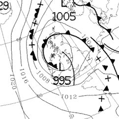
| 14th October 2011: A fine October day | |||||||||||||
| High
pressure was centred to the east bringing a light south-easterly
from the Continent. As the day dawned, the clouds were hardly moving
but gradually the wind picked up from the south-east, and then
turned north-easterly during the day. For a while, a sea breeze
brought a rolling cloud bank in, but this was disrupted as the wind
changed direction and the sun broke through. Extremes and totals for 14th Oct 2011
|
|||||||||||||
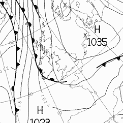 Met Office Chart 14/10/11 |
|||||||||||||
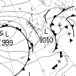
| 4th September 2011: A fine late summer's afternoon then a cold front approaches | |||||||||||||
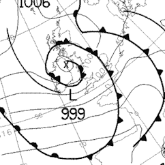
| Low
pressure was approaching the north of the British Isles with a cold
front. The video starts with fair weather cloud (cumulus) but then
cloud increases as the cold front arrives with rain. Note how the
cloud speed accelerates and the wind direction is from the SW. The
front passes over at 19:20, the sky clears and the wind abruptly
changes direction to the NW, the temperature also drops several
degrees. Extremes and totals for 4th Sep 2011
|
|||||||||||||
 |
|||||||||||||
| Met Office Chart 5/9/11 00:00 | |||||||||||||
| 29th August 2011: A fine late summer's day with cumulus | |||||||||||||
| High
pressure was building in from the west bringing settled, and
eventually warmer weather with more sunshine and lighter winds. Extremes and totals for 29th Aug 2011
|
|||||||||||||
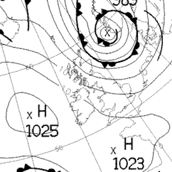 Met Office Chart 29/8/11 00:00 |
|||||||||||||
| 26th August 2011: A rainy ol' day with just a bit of brightness at times | |||||||||||||
| The
British Isles were under the influence of slack low pressure systems giving an unsettled spell of weather
with showers and longer outbreaks of rain. Extremes and totals for 26th Aug 2011
|
|||||||||||||
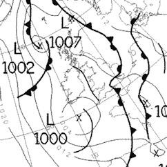 Met Office chart 26/8/11 00:00 |
|||||||||||||
| 24th August 2011: A showery summer's day in two minutes | |||||||||||||
|
Westerly airstream associated with a
series of low pressure systems giving an unsettled spell of weather
with showers. Extremes and totals for 24th Aug 2011
|
|||||||||||||
 Met Office chart 24/8/11 00:00 |
|||||||||||||
| 8th June 2011: Fair weather cumulus on a summer's afternoon in one minute | |||||||||||||
|
A low pressure system sat over the NW of
the British Isles on the 8th June 2011 giving a brisk, cool
north-westerly airstream. Extremes and totals for 8th June 2011
|
|||||||||||||
 Met Office chart 8/6/11 00:00 |
|||||||||||||
| 27th March 2011: A fine, if rather hazy spring day day in one minute | |||||||||||||
|
The day was a hazy one as the air mass was of Continental origin and there was little if any wind to 'blow' away the thick haze that caused the horizon to disappear into a white murk.
The movie is composed of 3500 separate images taken 30 seconds apart and then played at a speed of 30 images a second. |
|||||||||||||
| 20th March 2011: A fine spring day day in one minute | |||||||||||||
|
The day dawned with patchy cloud but by mid-morning the cloud had melted away and the sun shone all afternoon. A maximum of 15.5°C with light winds made it feel quite warm in the sunshine. Note the wind shear just after dawn where the higher clouds (associated with a decaying warm front) are moving in from the west, but much lower level clouds are coming up from the south and rolling as they do due to the effects of shear. The movie is composed of 2500 separate images taken 30 seconds apart and then played at a speed of 20 images a second. |
|||||||||||||
| Home | Data | Live | Other Webcams | Station | Climate | Gallery | Contact | Links | |||||||||||||